NSSC Team Using Hongtu‑1 Four‑Satellite Cartwheel-Formation SAR Achieved Important Progress for Remote Sensing Applications of Complex Forests
Forests are the largest carbon sink among terrestrial ecosystems. The forest three‑dimensional (3-D) structural information lays a critical foundation for forest inventory surveys, above‑ground biomass (AGB) estimation, ecosystem monitoring and global carbon‑cycle research. Underlying terrain and forest canopy height represent two key parameters describing forest 3‑D structure. Nevertheless, in tropical rainforests with tall and dense canopies, radar signals suffer from complex volume scattering and limited penetration capability. Accurately recovering underlying terrain beneath forests and deriving true forest canopy height remains a key challenge in international forest remote‑sensing studies.
As a domestically developed Chinese satellite constellation, Hongtu‑1 implements the world’s first spaceborne multi‑satellite cartwheel‑formation architecture. Through a single‑transmitter multiple‑receiver bistatic interferometric observation mode, it can simultaneously acquire interferometric datasets with multiple distinct spatial baselines in one orbital pass. Its primary application is high‑precision topography mapping. However, over dense vegetated terrain, measured elevations are significantly biased upward by forest‑scattering effects, yielding a digital surface model (DSM) that corresponds to the radar scattering center instead of the underlying ground topography or digital terrain model (DTM). Meanwhile, the unique multi‑baseline bistatic interferometric dataset acquired by this cartwheel constellation delivers new observational capabilities for probing complex 3‑D forest structures. How to fully leverage the advantages of synchronous multi‑baseline observations to achieve high‑precision inversion of complex forest 3‑D structural parameters poses an important scientific and technical challenge for forest remote sensing applications of China’s cartwheel‑formation SAR.
Recently, a research team led by Prof. Yang Lei of the Key Laboratory of Microwave Remote Sensing, National Space Science Center, Chinese Academy of Sciences, has achieved major advances in using Hongtu‑1 four‑satellite cartwheel‑formation SAR for complex forest remote sensing applications. The work was completed in collaboration with Beihang University, PIESAT Information Technology Co., Ltd., and Brazil‑based consulting company, Canopy Remote Sensing Solutions. Taking the Tapajós National Forest within the Brazilian Amazon as the study site, the team exploited Hongtu‑1’s multi‑baseline bistatic interferometric strengths and built a joint inversion approach for underlying terrain and forest canopy height. The method enables simultaneous retrieval of underlying topography and forest canopy height over complex tropical forests. Furthermore, the team systematically analyzed how forest parameter retrieval performance varies with interferometric baseline configurations, offering new technical avenues for multi‑baseline InSAR forest remote sensing applications.
The Amazon rainforest in Brazil represents the world’s largest tropical forest and a key study domain for global carbon‑cycle research. Characterized by tall canopies and complex vegetation structures, it serves as a canonical testbed for evaluating spaceborne InSAR forest‑sensing capabilities, as X‑band radar signals hardly penetrate to the underlying ground. Targeting the scattering signatures of complex forests, the research team utilized multi‑baseline observations synchronously obtained by Hongtu‑1’s four‑satellite constellation to construct statistical models of forest interferometric phase. Combined with spaceborne LiDAR observations from GEDI and ICESat‑2, robust retrieval of underlying terrain was realized. Forest canopy height was subsequently inverted by inverting a forest electromagnetic scattering model. The study also systematically characterized how different spatial baselines govern forest parameter inversion performance, delivering important references for observation mode design and data exploitation of China’s cartwheel‑formation SAR for forest applications.
Results demonstrate that multi‑baseline bistatic InSAR data from Hongtu‑1 can effectively retrieve underlying terrain and forest height information for complex tropical Amazon forests. Validated against spaceborne LiDAR (GEDI, ICESat‑2) and airborne LiDAR datasets, inversion outputs show good agreement: the absolute uncertainty of retrieved underlying terrain reaches 3.6 m (corresponding to approximately 70 % error reduction), and the relative error of forest canopy height retrieval is around 20 %. These outcomes illustrate the capability of China’s cartwheel‑formation SAR for 3‑D structural characterization of complex forests.
This research extends Hongtu‑1’s scope beyond conventional topographic mapping and expands its applications to forest remote sensing. It delivers new technical support for China’s novel formation‑flying SAR systems to serve forest resource monitoring, ecological environment protection and global change research.
These findings were published in the IEEE Journal of Selected Topics in Applied Earth Observations and Remote Sensing (IEEE JSTARS) under the title “Baseline‑Dependent Retrieval of Underlying Terrain and Forest Height From Hongtu‑1 Bistatic X‑Band InSAR”. Gang Jing, a postgraduate student from Beihang University, is the first author. Corresponding authors are Prof. Yang Lei and Prof. Fei Gao (from the School of Electronic and Information Engineering, Beihang University). This work was supported by the National Key R&D Program of China led by Prof. Yang Lei serving as the Chief Scientist.
Paper link: https://ieeexplore.ieee.org/document/11578218
See also: https://www.sciencedirect.com/science/article/pii/S0034425726003081?via%3Dihub
(Contributed by the Key Laboratory of Microwave Remote Sensing, National Space Science Center, CAS)
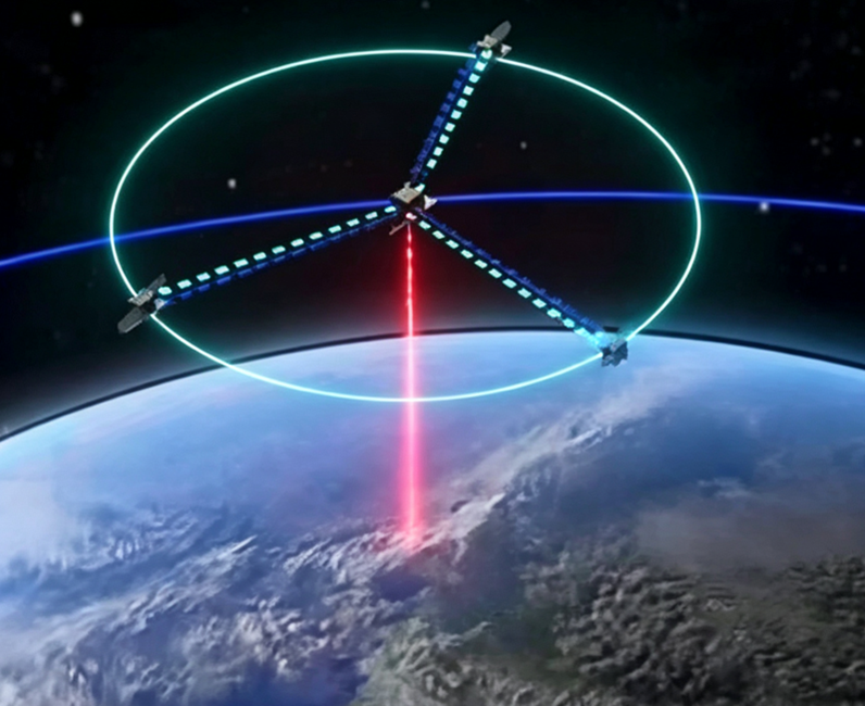
Figure 1. Schematic diagram of Hongtu‑1, an X‑band four‑satellite cartwheel‑formation bistatic InSAR system.
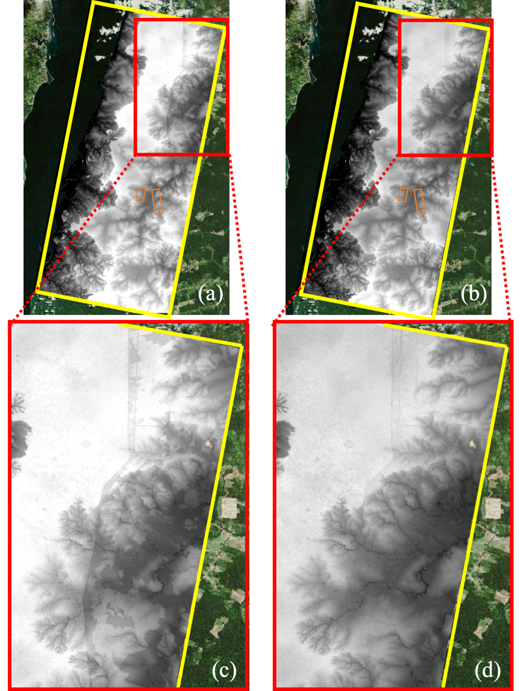
Figure 2. Copernicus standard DEM product (left) versus the Hongtu-1 retrieved underlying terrain product over Amazon rainforest (right). The right panel eliminates elevation discontinuities and biases within forested areas observed in the left panel.
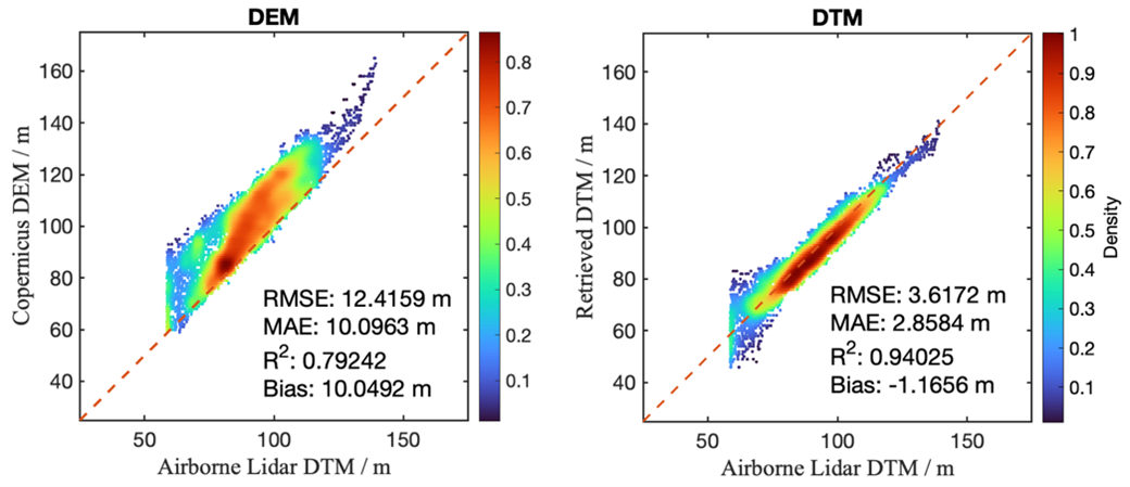
Figure 3. Accuracy validation comparing the Copernicus standard DEM product (left) and the Hongtu‑1‑retrieved Amazon rainforest underlying terrain product (right) against airborne LiDAR‑derived underlying terrain data. The right panel mitigates elevation biases over forested areas seen in the left panel and substantially reduces measurement errors.
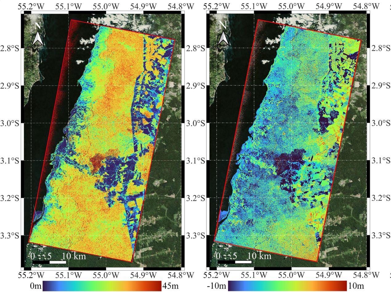
Figure 4. Forest height product of the Amazon rainforest retrieved from Hongtu‑1 (left), and height changes induced by deforestation and forest degradation across Amazon forests during 2015‑2023 (right).
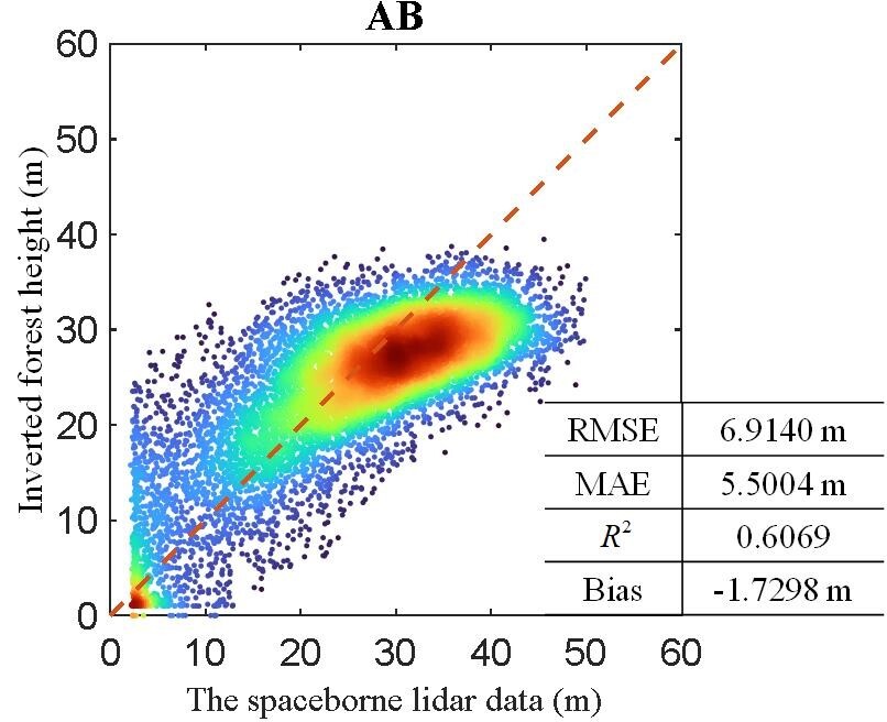
Figure 5. Accuracy validation of the Hongtu‑1‑retrieved forest height product for the Amazon rainforest against spaceborne LiDAR forest height references.